Tuesday, December 11, 2018

December 2018


In which we leave the States and head to warmer climes for the winter.

The start of December saw us on passage from North Carolina to Bermuda. To say that were ‘ship shape and Bristol fashion’ would be stretching things. Our radar wasn’t working; our dingy wasn’t holding air, so might need replacing – probably easier in the States than Caribbean; on the second day out, we discovered that our main VHF radio was again not receiving but worst was the lack of recency of the crew. We had had only one day of sailing, in fairly benign conditions in the last six months. Elsie frankly admitted to terror; I hid mine. On the plus side, we knew the boat well and had done longer passages in the past; we were full of fuel water and food; we had confidence in our ability to get weather updates and the forecast showed light winds, all from behind the beam. We would have been happier waiting a few more days and getting a bit more recency in but winter was pressing in and the longer term forecast didn’t give any other weather window for weeks. We had had a little trepidation over crossing the Gulf Stream, it being an axiom that you don’t do so with any significant North in the wind. As it was, we hit it at a quiet patch and although, at times, we could see a 2-3 northerly drift, you wouldn’t know it from the surface. What was amazing was the change in temperature. Only 150 miles from the coast, where night temperatures had been below freezing, it was now warm enough to put away several of the layers of clothing we had worn the first night out.

On departure, our 4 different weather models had given us widely different ETAs. By the morning of the first December, they started to agree that we would arrive around sunset on the 3rd. The weather overnight 3rd / 4th looked a little lively and the entrance to St George is a bit technical for an after dark first attempt so we needed to keep our speed up. On cue, the wind dropped and swung directly behind us so we started the engine to give us some assistance. It’s not something that we like to do for long periods but flexibility is good. The wind picked up again late in the evening and came round to just behind the beam, giving us a nice reach in smoothish seas and 8 knots through the water – heaven. It went up and down a bit over the next couple of days, giving us some nice reefing practice but we managed to keep ahead of our predicted speed and arrived off the coast of Bermuda at lunchtime on the 3rd with an hour to spare to enter in daylight. Our hope was to go to anchor and clear in with customs etc. the following morning but, just as we got to the entrance, we were instructed to go straight to the customs dock, which meant bringing in the spinnaker pole, tidying away lots of ropes (preventers, guys, spare sheets etc.) and getting out fenders and mooring ropes. Twenty minutes of frantic activity had us prepared and all went smoothly with very friendly officials making handing over $70 seem almost a pleasure. Half a mile motoring across the bay and another half hour of tidying away and we were able to take much needed showers, break out a drink and toast another successful passage. We had motor-assisted for nearly 24 hours but got back into the groove and could relax until the weather gave us a window for the next leg.
Customs House, St Georges.

Tuesday was, as forecast, wet and windy so we had a day of doing very little, just a bit of cleaning, tidying and trying to sort our radio problem. Our fuel gauge also seemed to be hugely optimistic but that would have to wait as I could not find access to the sender. A new calibration might be required. Wednesday was better so we got out the dinghy. It now seemed to be holding air in (maybe grit in a valve on first inflation) though still letting a little water in. Our new, heavier, outboard was installed without problem and we went ashore for a look round the local town. Very scenic and touristy, with a hammed-up reconstruction of 18th century punishments as lunchtime entertainment. The local 
supermarket was also better than (and not as outrageously expensive as) we expected.
Back to Ruby for another easy afternoon catching up on a few jobs, including finding an easy fix to our radar problem (loose connection at the display unit). Unfortunately no such joy with the radio. We managed for most of last winter with poor range caused by a damaged antenna. We would just have to put up with our hand-held back up, with the knowledge that the main was transmitting if we needed to send out an alert.


Thursday was again windy, so we elected to stay on board again.
On Friday, we took the bus to the capital, Hamilton and on yo the other end if the island group, the Naval Dockyard. This is where the cruise ships tie up and is a real tourist trap, with plenty of craft shops to augment the usual. We had omitted to pack a lunch and ended up paying over $30 for sandwiches and tea. Stopping off in Hamilton on the way back gave us some comfort, as we discovered that we could buy spirits duty free, to be delivered to customs for us to collect on departure. 2 very nice litre bottles of rum for $36. I wonder if we regret not buying more. Saturday, we took another local walk round St Georges, seeing the unfinished church and, at the northern point of the island, a new luxury resort under construction. Sunday got progressively wetter and windier with severe S’ly gales overnight. We were well prepared with everything battened down and even the wind generator curbed in case it over speeded. We unleashed it on Monday and, at times it was giving us over 100 watts so soon caught up the backlog.
Unfinished church

We had been following the weather closely and, from about Friday onwards, Wednesday had seemed the day for departure so, on Tuesday, we had a last trip down to Hamilton then came bacxk to tidy up and prepare for our next 930 mile leg down to Antigua.


On Wednesday morning, we eves-dropped a couple of other boats discussing their plans. Chris Parker, the weather guru, was recommending a 24 hour delay as there was a large, 3 – 4 metre swell running from the previous day’s high winds. We ran our forecast again and confirmed that delaying would make us miss our weather window. It would be fine for the first couple of days but then we would be caught in a calm then, worse, be sailing into a headwind for the second half of the passage. Our reckoning was that it was worth taking early pain for later gain. Final preparations: securing below; rigging lines; a top up of fuel, then we checked out (not forgetting to collect our duty-free rum) and headed out at 1040 with 2 reefs in the main and most of the genoa in a WNW’ly F5. While in the lee of the islands, the motion was fine and we made good speed. As we sailed south, the swell increased and, rather than the even ocean swell we were expecting, it became irregular and confused, possibly by the wave train being broken up by offshore shallows. Our motion became very uncomfortable and we suffered one slide down a particularly large wave, crashing sideways into the trough. We were both shaken by this and neither of us slept much that night. The following morning we had a little respite as the wind, as forecast, decreased to F3 and veered round to the NNE. We were travelling much slower but the motion improved a little, though there was still a significant W’ly swell. I then discovered water in the bilge. Only a couple of gallons but Ruby is such a dry boat that it had us worried but it seemed to have ceased and there was nothing we could do but monitor.

We were now in trade winds which kept a fairly steady direction, between NE and E, and speed, F 4-5 for the next 2 days. We should have been enjoying this but the first 24 hours had shaken and tired us. Elsie was unwell, probably just sea-sick, but was unable to keep anything down and, unusually for her, to sleep. I was eating OK but not sleeping. On the night of the 15th / 16th, the wind veered further to ESE and decreased to F 3-4. This meant that we were fairly close hauled, which in turn meant well heeled to starboard. As our forward bunk is on the port side, this meant using the port quarter berth, next to the cockpit and engine. This became significant as the wind veered and decreased more on the 17th, requiring us to motor sail for prolonged periods to stay ahead of the forecast calm. During an occasional stronger wind period, we suffered a further unpleasantness when the clew of the first reef gave way. Our ‘new’ main (we have had it for over a year, but not sailed very far in that time) had been modified by the makers, North, and a poor choice of shackle, supplied by them, had sawn through the webbing supporting the clew block. We managed a quick jury rig but, looking at the rest of the system revealed that the line had chafed badly at the tack. Being out of sorts on this passage had led me into not properly doing my twice-daily rounds and I had failed to notice that it had been poorly led. We managed to stay ahead of the calm and finally made it into Jolly Harbour at 1225 on the 19th. What we wanted to do was just curl up and sleep but, unfortunately, you can’t do that. We dropped anchor briefly, to tidy up and have the first proper showers in a week then motored into the customs dock to spend an hour or so doing paperwork and paying our dues. They were kind enough to let us stay alongside for a further half hour or so while we had a quick shop, then back out to anchor in the bay to finally relax.

We now had quite a few maintenance projects and the festive season was rapidly approaching. Our liferaft was overdue for survey and re-pack, as we had been unable to get this done in the States; The main sail needed repairing; the radio needed repairing; we needed to replace the first reefing line and the shackles for the reef clew blocks needed replacing. Fortunately, we were in a good place for all of this. Jolly harbour has a good chandlers and all of the technical people seemed to have capacity to help. Lots of phone calls and well-loaded dinghy trips saw everything required go ashore. Now to investigate the bilge water. The initial few gallons had been filthy with fibre glass dust, presumably from repairs back in 2014. We had dried that up but now there was more and it seemed to be coming from the keel area. This was deeply disturbing and I feared that our sideways slide on the first day had loosened bolts. It was, however, trickling out from a cross beam, which had no bolts inside. Lots of investigation revealed that it was coming from the raw water cooling pump for the main engine, trickling down the heating pipes for our domestic hot water tank and emerging in the beam. It was an annoyance that the pump, which was only replaced a couple of years before, was leaking but it was so much better than the possible alternatives.


New clew for hammock
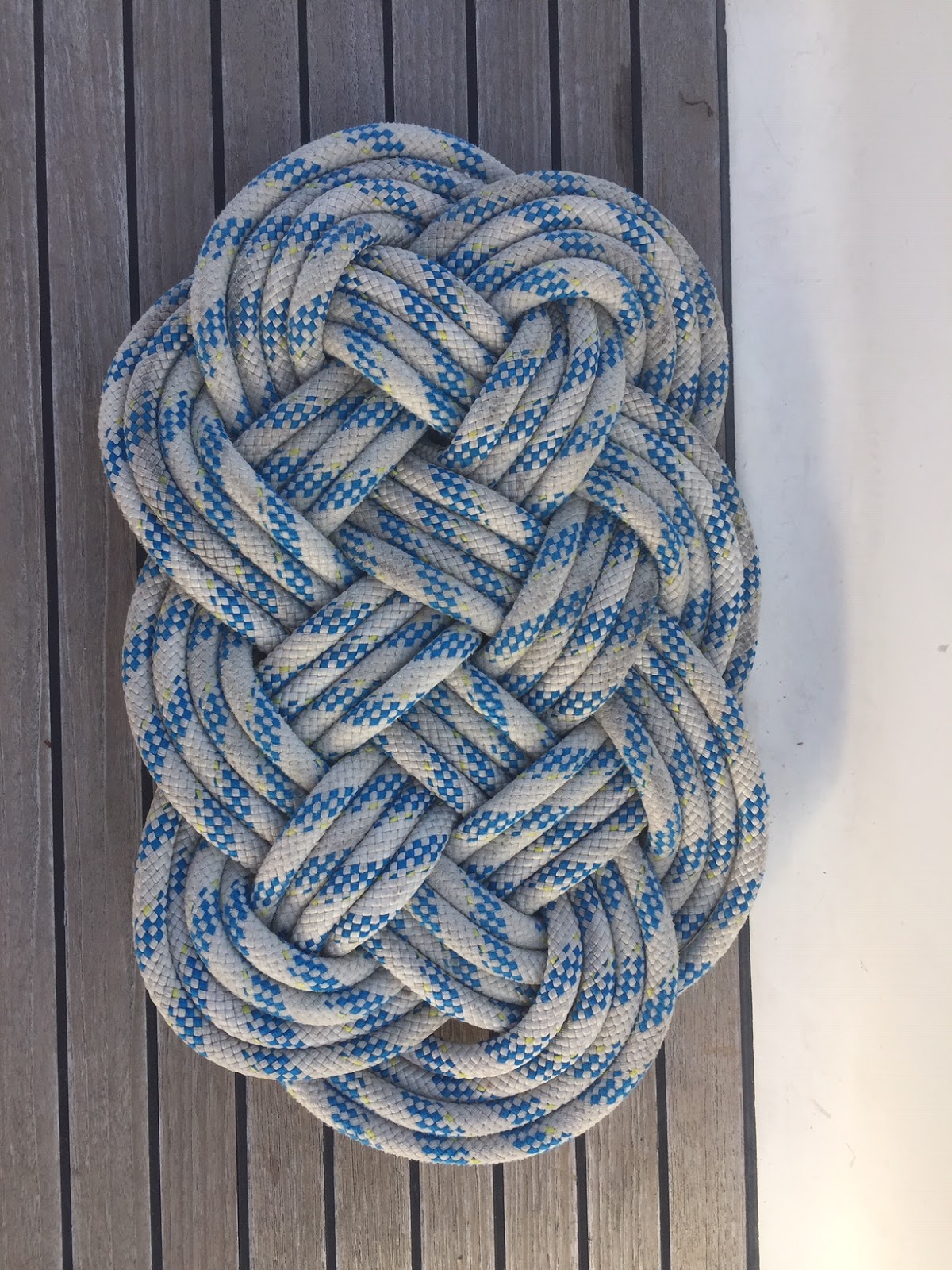
Carrick mat


Turks head on re-covered wheel

The next few days were spent with minor jobs, chasing repairers and, occasionally, relaxing in the sun or strolling on the beach. It became clear that nothing was going to be returned before Christmas so we bowed to that and made the best of it. We had a few socials with Ocean Cruising Club friends and got invited to BYO beach barbecue, courtesy of the local sailing club, on Christmas day. On the 27th, it became apparent that the radio and sail needed more active chasing so, on the 28th, after a final shop, we upped anchor and headed down to English harbour, anchoring in time to nip ashore, drop our old water pump off for investigation and collect a repaired sail and an unrepaired radio. The latter was an annoyance as the manufacturers had diagnosed the problem
by internet and were prepared to repair it at reasonable cost. Only problem was that they were 3000 miles away. We decided to continue using our portable set (Elsie having cured a charging problem) and take the main set back for repair when we could. We re-installed this set as we knew that it was transmitting and, at the very least, was one of our several ways of sending a distress message, if required.
Coldies coming ashore for Christmas Barbie on the beach

The anchorage at English harbour is rather cramped and, with strong winds forecast, I couldn’t put out as much anchor cable as I would like so, on Friday 29th, We motored round the corner to Falmouth and settled in. We attempted to re-install the main and managed to get the battens in but the wind blew up, so lashed it to the rail to await calmer weather. I woke the next morning to find, unforecast, light winds so dug Elsie out, with surprisingly few complaints, and 30 minutes later it was back on the boom. On Monday afternoon we were informed that our water pump was ready, so we picked that up. It was too late to check out so we spent the evening messaging friends and family as their New Year passed. At midnight there was a nice firework display and all the guests on the big yachts took their turn at blowing the fog horns. Eventually things quietened down and we went to bed to dream about 2019.

Monthly stats

Log                1620

Over ground  1372


Tuesday, December 4, 2018

November 2018

In which we return to Ruby after six months in the U.K. and prepare to sail off for the Winter.

We arrived back in Oriental on the 9th November. Two months earlier, the town had taken a direct hit from hurricane Florence. We had been informed that Ruby had suffered no damage but were anxious to check for ourselves. We had an initial panic – she was not where we had left her but soon spotted her on the other side of the boatyard. A quick walk round showed no scrapes or bangs and the inside was clean and dry – phew!

Ruby in slings, ready for launching.


We had a list of jobs to be completed before departure: the mast to go back up and electronics checked; wind steering lower mounting to be reinforced; servicing of main, outboard and generator engines and several smaller items. Our first disappointment was the decision by the rigger that the mast could not be safely installed while we were on the hard. The second was rain: the work on the wind steering had to be done on land and in dry weather. This meant that we did not get launched and mast installed until Monday 19th. By this time we had discovered other pressing matters: bilge pump not working; missing part for steering gear; outboard beyond repair etc. and I didn’t manage to connect the mast electrics until Wednesday 21st. I then discovered that the radar was not working. Thursday was Thanksgiving (as big as Christmas in the States) so nothing could be done until Monday. We had managed a myriad of other jobs, including installing a new toilet and Elsie had battled her way through the technology of our Iridium GO satellite device so we spent the weekend tidying, cleaning and even having a trial with our new, bigger outboard. This is when we had our next disappointment: our dinghy, though old and scarred, had always kept the air in and the water out. After six months of being rolled up in the locker, it seemed to do neither. Only slow seeps but it was really time for a new one. This would take time to order and we wanted to be away so decided to cross our fingers that it would last until we could find a replacement. Monday morning brought a radar technician who could find no obvious fault so, again, we crossed our fingers ( we had barely used it in the last 2 years) and finally, at 12:10 on Monday 26th, we let go and motored down Adams Creek back to Fort Macon and anchored for the night. On Tuesday, we went out for a day sail, to Lookout Bight and back, to check the rigging (too loose), the wind steering (working) but mostly ourselves. We had had six months off and needed to be reassured that we still knew how to do it. We came back in to Homer Smith’s marina to make final preparations. One last disappointment awaited us as we discovered that our main radio was not receiving and we resolved to fix this the following day.


Re-fitting the mast.

Our plan for the winter has been to head to Antigua, drift west with the trade winds through the Leeward Islands. Virgins. Puerto Rico, Dominican Republic, Jamaica and Cuba and then make a decision in the spring whether to re-cross the Atlantic to Europe. The way the weather systems work, the natural route from the east coast of the United States to Antigua takes one within about 100 miles of Bermuda so we planned to use this as a staging post, breaking the journey down to manageable sizes of about 600 and 900 miles. This sounded fine while we were sitting in the U.K. but now we were faced with the reality: these were long ocean passages and we were six months out of practice. The alternative was to coast-hop down to Florida and cross to the Bahamas, as we had last year. This would have been a lot more comfortable but we would then have been trapped by the trade winds. Sailing east in this area is known as ‘the Thorny Path’, beating hundreds of miles into the winds or taking advantage of short term conditions to make small, mostly night, hops, relying on the weather for your destiny.

Our ‘shake down’ day sail had gone well and a weather window for the leg to Bermuda had opened up for Thursday morning. We decided to take it. The radio seemed to have fixed itself, so it was a case of tuning the rigging, doing laundry, topping up on fuel, water, food and beer and checking out with customs. All this was achieved in time for us to meet up with 3 other Offshore Cruising Club members and the Port Officer for a great meal of local shrimps, snacks and drinks. All 4 of us were planning to leave the following morning, each with different plans: Blue Velvet was heading direct to Antigua; Coolchange for Charleston and Enjoy going South on the ICW. To say we slept well that night would be stretching things. Elsie admitted to terror; I did the manly thing and showed a calm exterior. Intellectually, we knew that we, and Ruby, were capable but the voyage ahead was daunting.


Flags hoisted, ready to sail.


A few minor tweaks on Thursday morning and we were off, just before 10 AM. As ever, we had to battle the tide leaving Morehead and then had light winds sailing for the first 24 hours, which gave us time to get our sea legs back. The next 24 built to a Force 5 W’ly giving us a great broad reach and a little practice in reefing. We were checking the weather every 12 hours. We can get 4 models and each gave us a slightly different ideal route and ETA. Our philosophy is ‘Hope for the best; plan for the worst’, so we weight each model, avoiding anything that looks nasty and modifying our route to try and achieve best speed while keeping the wind behind the beam when possible.

Monthly stats

Log               277

Over ground  276

Oops - late posting. Summer plans.

Elsie wrote this months ago but we didn't get round to posting.


Well that was The Bahamas and this is the south of England???

Talk about contrasts. I have spent the winter floating around paradise. The only major decisions taken were which beautiful Island or Cay next. OK, the weather was not perfect but it does add something to the journey, the uncertainty, the joy of a sailing wind, the disappointment of a force 8 instead of a force 4, the wind unpredictably backing, setting the cruising chute on the port side then realising, ten minutes later, that it should have been on the starboard. Yes, it was frustrating sometimes but the compensation for that frustration was visiting the most perfect beaches anyone could imagine or finding little homesteads of half a dozen houses and a school with five pupils. I loved it.

One of the best things about the Bahamas is everyone can find what they want or need. There is room for every type of sailor (or visitor) in this group of perfect islands. Large marinas with every facility that can be imagined, night life, bars, coffee shops, sophisticated restaurants, shops selling designer wear – they can all be found. Some of the islands are just an extension of Florida for those people who only feel comfortable in an environment that is familiar. There are sociable anchorages where people organise pot luck suppers and get together in beach bars. There will be a supermarket selling recognisable food, a laundry and hire cars available. But if you look hard enough you can still find deserted islands with no facilities, large and small cays that may or may not be shared with an occasional local fishing boat, tiny anchorages with just about enough room for one boat, long long deserted beaches who have only your own footprints in the sand. Yes, there is something for everyone in The Bahamas.

I enjoyed our time there. We used it as a winter to slow down and smell the air. To stop rushing around from place to place and enjoy the place. It was sometimes very difficult. Everything is weather dependant so when it rains there is not much to do. There are no ancient ruins to go round, or art galleries to peruse. There are very few cinemas and shopping malls usually consist of three shops in a row selling tacky souvenirs or boat bits with an occasional hairdresser thrown in. When the wind blows form the wrong direction AND it rains it is sometimes impossible to even get ashore so the entertainment has to be found on the boat. Luckily we are both avid readers and use the sailors book swaps constantly, we can loose an afternoon easily with our noses pressed in a book. In the evening radio podcasts are our entertainment, the Archers being the favourite but Lionel has also introduced me to The Navy Lark, Cabin Pressure, and Andy Hamilton’s brilliant serial about hell and the devil, just to name a few. We also have games onboard which can become very competitive. I have gone to bed not talking to Lionel because he won three out of three games in one night. I know very childish but he can be so smug about it.

I found it very difficult being stuck in one place for a week at a time because of bad weather. Of course when the wind blows the correct anchorage has to be found for the particular wind direction so you are forever thinking three or four days ahead when you are on the move. Being a member of a Facebook forum can be a blessing but it can also be a curse. People exaggerate or pass on wrong information or information that has been interpreted into what they think the expert meant. We learnt very early on in the winter to listen but make up our own minds when weather issues were discussed. Some people won’t move a matter of a couple of miles without the weather experts say so. What they don’t realise is what they are missing (but maybe that’s a good thing because the deserted anchorages would not be so deserted if people made up their own minds). However, Facebook was a good way to keep in touch with other sailors and get recommendations about places and anchorages.

We made it further South than we anticipated this winter, all the way to Great Guanya, 50 nm from Cuba. The Island was totally different to the others as it had a definite function and was not full of tourists. Morton Salt Company seemed to run the Island. Most of the land were huge salt pans, filled with sea water that was continuously pumped into canals. The salt was harvested by huge machines and the salt was piled up in enormous white hills awaiting for a ship to deliver it to be processed to Atlanta. Most of the population worked for them, the grocery store and most of the houses were owned by them. I did ask myself the question “is this a modern way to enslave people?” but the population seemed to be prosperous and happy so the partnership worked. The Haitians sailed here in traditional sloops to trade with the islanders. Maybe trade is the wrong word. The boats were empty when they came and full with all manner of useful, and sometimes useless, things. We saw a sloop sail out of the harbour (they have no engines) with a three piece suite tied onto the deck.
Yes, The Bahamas were a contrast of differences. I personally loved them. We could find the peace and tranquillity that we sometimes crave but there were sociable anchorages with something going on most of the time if company was needed. Deserted beaches a plenty, reefs to snorkel but always a shop or eatery a days sail away to get supplies. Yes, my winter was wonderful although I wouldn’t want to do it every year as the Snow birds do.

We left early. We didn’t need to go until the middle of May but when a good weather window appears you jump. The journey back to the States was “awesome”. Passing Great Bahama we got our last weather report. It was not good. There was storms predicted for two days time but knowing how the weather changes dramatically from day to day I was not happy to continue to Charleston so I persuaded Li that we should head for St Augustine. Looking back I was wrong, we would have got into the shelter before the storm hit but I was and will always be very cautious when doing long passages. We eventually found the Gulf Stream and rode it for 22 hours. It added about 6 knots onto our speed. With regret we jumped off and headed west towards St August and Officer Dibble. Loyal readers will know about Officer Dibble from our last entry into the good old U S of A. This time he was as bad, although we did not get separate interviews and he did crack a smile…….once. The weather deteriorated quickly and that was our only trip ashore before we sailed to Charleston. Not a good passage but we got there and we found ourselves anchored beside one of our favourite cities in America. For the next week, we made our way slowly towards Oriental, Ruby's summer home, some of it offshore, some through The Ditch. We arrived, we prepared Ruby to face a whole summer alone on the hard. It was hard to leave her but I think she is in safe hands, ready to face whatever Mother Nature throws at her and lots of friendly people looking after her.

On our way home, we went via Washington (thank you Susanne) and New York. I think I have “done” New York and feel no great urgency to visit again for a very long time. Washington has so many different experiences and I still haven’t seen them all so I may return. We landed back in Scotland and immediately started our new adventure – pet sitting. The whole summer stretched out with over a dozen pet sits in so many different places. From Inverbervie near Aberdeen to Penzance Cornwall. From large Newfoundlanders to Welsh Terriers and chickens and cats thrown in. We are approaching this new adventure as we approach everything new we face, anticipation of all the lovely places we will stay, terror of looking after unknown pets, joy of meeting old and new friends along the way and the whole uplifting feeling of starting a brand new adventure. Wish us luck, we may need it.

Wednesday, April 11, 2018

April / May 2018

In which we sail back to the East Coast of the U.S.A. to leave Ruby for the summer.


We began April at Elsie’s favourite island – Conception. We didn’t have it to ourselves but it was good to relax after our, more exciting than expected, voyage up from Mathew Town. Just one trip ashore, to walk the beaches and photograph the ‘mashed ship’ that I had spotted last time here.
Mashed ship
A period of calm was coming up and we decided to make our way towards another favourite spot to wait it out there. On Monday 2nd, we heaved up at 0830 and headed towards the bottom of Cat Island on a broad reach. Up past Hawks Nest point and then close hauled across The Bight to Fernandez bay. Elsie took charge for the day and enjoyed an unofficial race with another boat, who changed his mind and went up to New Bight instead. On arrival we found a beautifully sheltered spot for the night, moving a mile up the coast the following morning to dinghy into Smith’s Harbour for provisions. There was conflicting advice about the state of the harbour but we could easily have brought Ruby in and, maybe Med Moored to the dock. Back on board, we had a fine beam reach up past Alligator point then close hauled into Bennet’s Harbour for a relaxing afternoon. On the 4th, we had a short sail up to Orange Creek, anchoring close to the town and dinghying in. The entrance has strong currents and was a bit splashy but we were delighted to find that our chosen landing spot was directly opposite the store which was not only well provisioned but were able to fill our cooking gas tank and let us get our laundry done. A well spent afternoon.

In the morning, we motored a mile or so away along the coast, just for the privacy. Later that afternoon, I spotted a local walking his boat along the beach, took pity on him and gave him a tow back to base. We then went ashore for one of our favourite walks, though we were aggravated to find one other person on our private 2 mile beach. Friday the 6th gave only light winds, so we stayed put for another lazy day then, on Saturday morning we heaved up and broad reached back to Little San Salvador under main and cruising chute in a southerly F3. Our ‘usual’ anchorage at the north of Half Moon Bay was pretty rolly in this wind but today’s cruise ship obligingly left at 15:00 so we scuttled across to the southern side for a comfortable berth, dinghy ashore and walk along the beach.
Beach cabanas at half moon bay
Our next planned stop was Highbourn Cay at the top of the Exumas. There are strong currents at the entrance so wanted to make it near the high water slack in the middle of the day. To do this, we planned for a 5 O’clock departure. As we were both awake at 3, we brought this forward and were underway at 03:30. A northerly wind had been forecast for overnight but this changed so we decided to anchor in the north bay, with a big, wide entrance where we could have arrived at any time. Anchor down at 12:20 and a lazy afternoon. Well, it was Elsie’s birthday! We were away again at 08:00 on the 9th, heading for Nassau. The plan was to cruise through the harbour and anchor in a bay to the west but we made such good speed under main and chute that we decided to anchor in the harbour, opposite the excrescences of Paradise Island and have a wander ashore. We walked up to the cruise ship terminal for a gawk and an ice cream and then back to the local’s area to find our first proper supermarket in over 4 months. Elsie was pretty excited at both.
Two boats in Nassaua

Paradise Island, Nassau

Cruise ships
The weather forecast was again changeable so we decided to top up on fuel the following morning before heading out. Today, the wind was disappointing and we made slow progress up the eastern side of the Berry Islands under main and chute, sometimes goose-winged and sometimes broad reaching. Eventually, we motored for a couple of hours to reach Great Harbour Cay, dropping anchor at 1835. I wanted to be well up as anchorages on this side would provide no protection from the northerly and easterly winds forecast for the following 24 hours. As it happened, there was an unforecast front that night with gale force northerly gusts. This caught many by surprise, especially in the Abacos where it went up to 50 knots, causing a few dragged anchors. To find shelter, we picked up at 0800 on the 11th, sailed up to the top of the islands, past a couple of cruise ships discharging their passengers onto purpose made resorts on Great and Little Stirrup Cays, back down and into Bullock’s Harbour. 22 miles on the log to move 2 miles. The water here was green and the bottom was grassy but the anchor bit first time and I gave it an extra tug to make sure that it was well bedded in.  The wind, for once, behaved exactly as predicted so we spent a comfortable night and rose the following morning ready for a big hop. The hope was to make it in one go to Charleston, S.C., with St Augustine, Fl, as an alternate.
Making 11 knots across the ground, courtesy of the Gulf Stream
Up anchor at 0810 on the 12th and broad reached away in a F4 easterly, with one reef in the main, heading for the south-west coast of Grand Bahama and the Gulf Stream. By late that evening, we were off Freeport and back in internet coverage to update the weather. This did not give us good news: we could certainly make St Augustine but there was a strong front forecast for Sunday and, if we were late, or it was early, continuing up to Charleston could expose us to some very strong winds. So, the fall-back option was selected. We continued heading north west, to find the Gulf Stream then caught a ride north with a 4 knot assist. By this time, the wind had veered to just south of east and we had an easy motion, with 12-14 knots of wind giving us 6-7 knots though the water and up to 11 knots over the ground. On the evening of the 13th we, reluctantly, altered course, set the sails for a run, and headed for St Augustine, arriving at the fairway buoy at 0900 on the 14th and anchoring just below Vilano bridge at 10:15. I spent an hour trying to resurrect our phone SIM from the Autumn, then we caught a water taxi ashore to book in at the airport, get a new Sim and some provisions before getting back on board, very tired at 17:30. A quiet evening was had.
Twister!
We had hoped to spend at least some of Sunday catching up with our local friends, the Gaults, but strong winds were forecast, with a local tornado warning. The winds arrived in the afternoon with a violent frontal passage and a tornado crossed the harbour though, fortunately, not us. Monday and Tuesday looked good for further progress, with a hiatus of a few days after, so we picked up on Monday morning and headed for Charleston. The wind was W’ly F5, which I hoped would give us a good speed with low swell as we were staying within 20 – 30 miles of the coast. We were disappointed as, with the water being only 10 – 15 metres deep, it kicked up an unpleasant short, steep sea. The speed was good but the motion wasn’t. The wind increased to F6 after dark and I put the 3rd reef in before Elsie’s night watch which was as well. The wind continued increasing and she had F8 for a while. Of course, it dropped and veered in the morning but we managed to sail up to the fairway buoy before starting the long motor, against the current, up to our anchorage opposite the City marina. Having arrived and tidied up, we had another long look at the weather. The forecast had changed and it now looked good(ish) for the next few days with following F3-4 winds. The only problem was in the small print which warned of gusts of up to F7.

After the experiences of the night before, we agreed that this was not a forecast for single watch-keeper night sailing but we worked out a series of day hops. So, on the18th, we picked up anchor at 0700 and motored, against the tide, for 2 hours back to the entrance, passing the isolated anchorage we should have stopped in the day before. Today, the wind behaved and we had a fine goose winged run 45 miles up the coast to Winyah bay, on the approaches to Georgetown. We motor-sailed 3 miles in, naturally against the tide, and anchored in a slightly lumpy spot. Another early start on the 19th, catching slack water – hurrah – and another goose – winged run up to the little river inlet. There was an anchorage marked just inside the breakwater but the depths we found were less than charted. There was another, 2 miles further on, just across the Inland Coastal Waterway which gave a promise of more shelter from the wind. Another 30 minutes of motoring, look both ways crossing the ICW, into the creek and… slide to a halt. Less water than charted again and, this time, we grounded in soft mud with another foot for the tide to fall. One option was to launch the dinghy, run out anchors, wait for the rising tide and warp ourselves off. The other was to do what the locals do. At the boat show, last October, I had taken out towage insurance with BoatUS for just such an eventuality. A quick phone call and 30 minutes later a large RIB with twin 250 horse outboards arrived. A good briefing from its skipper, towing bridle attached and rescue was underway. He quickly turned us round but it took a further 30 minutes of him sawing back and forth to free and tow us the 5 metres back to deep water, and a further 15 minutes took us back to our original anchorage. This time, I accepted that we would be closer to the marked channel than ideal and dropped the hook 2 hours later than planned.

We had one more day of good sailing weather. The wind was veering to the North but would assist us along this next bit of coast to Cape Fear. Here there is a 30 mile shallow reef extending out to the South East and we were electing to take an inland short cut from Southport to Wilmimgton. Elsie had found us a nice (cheap) marina halfway along this route but it has a shallow entrance and strong cross currents. Sitting with my planning tools, I calculated that, departing at first light, we needed to average 6.5 knots along the coast to catch the tidal streams along the Cape Fear river, so up at 6 and away at 06:40. Unfortunately the wind had veered more than forecast and, instead of it being on the beam, we were close hauled and could only make 5.5 knots in the choppy sea, so the engine was re-started and we motor sailed along, hitting the channel 5 minutes before my target of 11:00. Down with the sails and a 14 mile motor, with following current (and a large container ship), up to Carolina Beach State Park marina. This was a friendly little place, with power (first time we had plugged in for a year) and water (Ruby got a much needed wash-down) included. With a washing machine available at $1 per load it was also time to catch up on laundry so Saturday was a busy day of cleaning. After this we made like the locals and ‘hiked’ along a ‘trail’ through the park.
You've seen house boats; this is a shed boat
A further job for Sunday was end-for-ending the anchor chain. We have had this one in almost constant use for 18 months and the working end is starting to show signs of wear, so I wanted to turn it round and use the other end. When in Conception Island at the start of the month, there were free mooring balls available, crystal clear water and clean sand to lay the chain on and I considered doing the job there but procrastinated. Now, we lowered the anchor onto the pontoon and the chain into the water, swapped ends and started to haul it back in. UGH! I was expecting a bit of mud but this was awful and we had to wash it off, one foot at a time, taking twice as long as the rest of the job. Once finished, we had a final trip to the supermarket and left, just before 3, to make 11 miles further through the cut to poise ourselves for the last leg to Beaufort, whether in- or off-shore. The inshore route would take us 2 days along the ICW, with many bridges and few good anchorages; off shore, although we could do it in one, long, day the forecast was not good with strong Easterlies. We anchored at Wrightsville beach for the night and rose at 7 expecting to motor up to abeam Jacksonville. Looking again at the forecast, it now showed very strong winds for Monday night / Tuesday morning. There was only one suitable anchorage at half distance and this is owned by the military, who reserve the right to kick visitors out at short notice. While we were havering, an un-forecast rain shower arrived and we decided that, as we were well ahead of schedule, to stay in our nice, comfortable spot and have an easy day.

That day was followed by another, as Tuesday morning was, indeed, foul and we saw a possible window for sailing across Onslow Bay on Wednesday. Up at first light and on our way by 0710 in light airs – no matter, we would rather motor in open waters than up the ICW. Two other yachts followed up the mile or so down to the entrance and we thought that we might have a little flotilla but they both turned inland heading for the ditch whether North- or South-bound we could not tell. We had rigged a mainsail preventer to port and the pole to starboard and, by 10:00 the SSW’ly wind had picked up enough for us to goose wing with full sail. It then, conveniently, backed sufficiently for us to broad reach and we made good progress across the bay arriving at the entrance to Moorehead at 17:00 with just a short motor to anchor near Fort Macon. There are strong currents on the section of ICW up to the Neuse river and, with an ebb tide in the morning, there was no point in starting early so we filled Thursday morning with preparations for laying up, including dropping the genoa and tidying away lots of lines etc. We picked up at 14:00 and headed up, motoring. The current was initially with us but, for most of the way, we had about a knot against us, which was a disappointment even though we knew that tides in Pamlico sound are more influenced by wind and rain than the moon.

We arrived at Oriental at 17:45 and headed to the Harbour Marina, where we were, very generously, being lent a berth by fellow OCC members, Don and Dierdre Wogamon. The following morning I headed into town to meet some of the people who would be looking after Ruby and various bits of her over the next few months. First stop was Seacoast Marine electronics where Peter reckoned that he should be able to assist with our VHF, plotter and wind indicator. Next to the boat yard to meet Alan the owner, Dan the fabricator, Travis, the rigger and, of course Tammy who runs the whole operation. Got a very positive response from all and picked a parking spot for Ruby. Then to Inner Banks sails, to discuss sundry canvas work, including a new bimini cover. Finally to Hodges street sails to arrange for repairs to the genoa and a wash for the chute. The latter called round to collect the sails and promised a report in a day or two. Saturday morning, we had a lie-in then a wander round to the farmers’ market (a little underwhelming) and a good browse round the local chandlery before returning to Ruby and further chores. Disappointment in the afternoon as Hodges Street Sails returned ours as they were too big for their loft but delight in chatting with the owners, Laura and Gil: definitely ‘our sort of people’.


Oriental has a dragon theme!

Post box


Dragon's egg

Warning sign


Lawn dragon


Sunday morning was spent on further cleaning and tidying then a walk in the afternoon took us to Mildred Street, to meet the OCC Port Officers, Ann and Nev. Again, lovely people and we congratulated ourselves on having chosen this place to leave Ruby. As previously mentioned, the tides here are driven by the wind and a check on Monday morning showed that Southerly winds were forecast for later. We had been planning to move round to Sailcraft Service the following day, to lift out on Wednesday but, as we were tight on entry depth anyway, decided to go early. This was a good decision, as we showed a clearance of 10 cm in places and, by Tuesday, the water level was 20 cm lower, staying that way or worse for the rest of the week. We were expecting to raft up, in the water, for a couple of days but were ushered into the boatlift and hauled straight out. There now followed a hectic couple of days: cleaning, sorting, chasing various people to ensure jobs were going to be done and decisions to be made, including to replace the jib furler and a bit of socialising in the evenings: a great put-luck supper at Ann and Nev’s and the cruisers equivalent of a cocktail party at the gazebo on the dock. We had decided, for laundry more than anything, to spend Thursday night ashore and, once again Ann and Nev came up trumps letting us stay at theirs and giving me a lift to collect our hire car.
Ruby on the hard
Finally, on Friday 4th May, it was time to close Ruby up wish her a tearful farewell and drive off for our next adventure: 5 months of travelling round the U.K., pet sitting in other peoples’ houses.


Thursday, March 29, 2018

March 2018


In which weather, in Scotland and the Bahamas, delays our progress but we make it as far South as Great Inagua before turning North.

Having been delayed by ‘The Beast from the East’ I finally returned to Elsie and Ruby at Emerald Bay Marina, Exuma, on Sunday 4th March. A weather window for exiting and proceeding to Rum Cay had passed 2 days earlier and Northerly winds were forecast for the next 3 days. The swell was augmented by a very deep depression in mid Atlantic, which had surfers raving about the ‘best’ waves for a decade from the American seaboard through to the Virgin Islands. We wandered down to the harbour entrance a couple of times each day to watch the water and, occasionally, a boat entering or leaving. There seemed to be a pattern – 3 or 4 huge waves breaking right across the entrance, followed by several minutes of unbroken, but still huge, swell. With the northerly wind, an engine failure at the critical point would rapidly leave you beam on to this and swept onto the rocks within a couple of minutes.
Beacon

Church door

Elsie had hired a car to collect me from the airport. $60 for the day compared to taxis at $30 -40 each way. It wasn’t much of a car but it did the job and we took a trip down to the bottom of Little Exuma that afternoon. We found a pillar which had acted as a beacon to guide boats in to collect salt when it was being harvested from ponds a century earlier and a beautiful little church with modern stained glass windows. And door. We also used the car for a fairly major provisioning trip on Monday, before fitting the new wind generator with help from a neighbour (and his tools). Tuesday and Wednesday were just spent weather watching with daily walks, either through the adjacent Sandals resort or a stalled private development.

Finally, on Thursday 8th, the wind shifted to the southwest. The swell was still larger than we would have liked but I figured that, if the worst happened with an engine failure, we would at least be able to sail clear. One false start, with a train of breaking waves coming sooner than expected, then a dash for freedom and 5 minutes later we were outside in fine sailing conditions, broad reaching the 47 miles back to Thomson bay on Long Island. Here we stayed for a further 5 days, moving twice to shelter from shifting winds and having the occasional trip ashore for a walk when they were not too strong.

At last, on the 13th, we saw a window to make progress to the East and Aklins Island. It was a round-about route to get shelter for overnight stops. First, we headed West, back through the Comer passage and down to Water Cay. The first bit was a fine beam reach and second leg was a slow run. The wind, which should have shifted to East of North, failed to do so but we were comfortable enough and, as it looked worse than it was, only one other yacht joined us so we had plenty of space. Our neighbour was a young American couple who were having a fairly torrid time beating to wind on a 40 year old, 30 ft yacht with no auto pilot or weather updates. They had been stuck in Florida, crossed to Cuba with only a 14 day permit and were looking forward to a bit of peace. We were able to give them the good news that, if they were prepared to motor into wind the next morning, they should then have a good sail into Thomson Bay. For ourselves, we decided that we would get better winds by waiting a day, so spent the 14th at anchor with a nice walk along the beach. On the 15th, we back-tracked a couple of miles North then broke free of the bank and into deep water for a 50 mile reach across to Gordons Bay at the south end of Long Island.  Most of the way, the wind was on the beam, so it was Elsie’s treat. She had to work a little harder for the final 10 miles but we found a comfortable spot and settled in for the night. The next leg, across to Aklins Bight, was 20 degrees further to starboard but unfortunately the wind veered 45 degrees so we had a 35 mile close reach the following morning. Once inside the bight, we had to motor for a while but got another nice close reach for the final 12 miles down to Camel point, which provided good shelter. Our days run of 62 miles being our furthest for a few months, we felt our sun-downer rum punches were especially deserved.

Having finally got to Aklins, we weren’t sure what to do next. Once again, using the available winds would take us to places with poor shelter or trick entrances so we decided to chill for a couple of days and just do a few little routine maintenance jobs. On the 19th, the wind shifted to the south and we re-positioned round the corner to anchor as close as we could to Spring Point settlement, where there was reputed to be a store. The nearest we could get still left us with a ¾ mile dinghy ride but our first impressions were good when a car coming in the opposite direction stopped to ask if they could help us at all. The next vehicle was an out-of service school bus going the same way as us. He also stopped to chat, told us that the local store was poor and he could give us a ride to a better one a few miles away as he was going that way anyway. We accepted. This store was acceptable (though no chicken!) and also had a restaurant attached and, as we had failed to make provision for lunch, we ate (good local fish, chicken or pork, with beans and rice). Our driver also ate and gladly accepted our offer to pay for him. While eating a loud discussion broke out about local religious affairs, in which our man appeared to be chief stirrer and we discovered far more than we wished to know. Having eaten, as he was now returning south, we accepted a lift back. In the absence of service buses, hitching is an accepted means of travel here. We have enquired and been told that payment is not expected and an offer may even cause offence, so I was a little surprised at the driver angling for and accepting a tip in addition to his lunch. It’s not wrong but it seems out of place here. Coupled with the theocracy (apparently 19 churches of various denominations for a population of about 600) it left a slightly sour taste. Probably not our favourite destination.
Lunch stop

We had been humming and hawing about whether, given the poor aid from the weather this year, it was time to head north but, looking at the long range forecast, we reckoned we could make one further trip south. To position ourselves for this, we heaved up on the morning of the 21st and sailed the 20 miles back across the Bight of Aklins to anchor near the entrance. Again, we ended up about ¾ mile from the shore and dinghied in to have a look at the small settlement of Albert Town on Fortune Island. There is a little pier, with a channel in marked by posts. Even following this, the water was very shallow and, on the return, we sat as far forward as possible to give a couple of inches extra clearance to the propeller, turning at minimum revs. To reach the settlement, we had to walk about a mile along a rough track to discover half a dozen houses, a telecoms office and a small beach. At least we got some exercise.
Returning from Albert Town


We wanted a daylight arrival at Great Inagua, a voyage of about 110 miles, so we elected for a late afternoon departure. A quartering wind of 15 knots was forecast and we should be able to average at least 6 knots. We could always slow down or heave-to if necessary. Accordingly, after a bit of routine maintenance of sewage piping (always a pleasure!), we heaved up at 15:00 on the 22nd and headed out, only to discover that the wind, for once, was lighter than forecast and that we had a north-setting current of up to 2 knots. It looked like we had miscalculated badly and might not make our destination in daylight. Apart from that, it was a pleasant sail, our first over-nighter since arriving in the Bahamas 3 months ago. The wind picked up a little, giving us a voyage average of 6 knots through the water (so, at least, I got that bit right) and the current reduced to about a knot. We arrived off Mathews Town at 13:00. Now, we had a further dilemma. The pilot book states that the small harbour is subject to surge and that there are obstructions and a shallow entrance, dangerous in a swell. We understood that the entrance had been dredged (and it was near high water) but there was a significant northerly swell running. There was an anchorage 10 miles further on, on the south coast. Having got trapped at Emerald Bay, we were wary of this harbour entrance and elected to continue. The chart, and book, suggested a comfortable berth, with clear sand and protection from swell, a mile or so offshore, inside a reef. The chart also hinted at a closer in spot so we headed for that, hoping that we would be able, the following day, to dinghy ashore, hitch into town and check the harbour for ourselves. We dropped sails at 15:00 and tried, unsuccessfully at the closer in one, but found poor holding, so went to the recognised anchorage. Either coral grows very quickly here or other peoples’ idea of clear sand varies from mine. We did eventually find a clear area, dropped the hook, and settled for the night, though it was not as smooth as we would have wished. The following day, with the wind still in the same direction but stronger, the swell changed direction making it even more uncomfortable. As an experiment, I attached a second line from our anchor cable to a midships cleat. This veered our bow round, making us pitch rather than roll. We spent a second uncomfortable night. In the morning, the wind had veered and decreased so we decided to pick up and head into town. By now, we were pitching heavily and had extra cable out from the previous days manoeuvres. The chain caught a couple of times on a coral head resulting in distress to both. Elsie had had a bad night so we just motored back to Mathews Town. We gingerly approached the harbour, to find it clear, with brand new docks, no surge and 15 ft of depth. It being Sunday, there was no-one around. There was a concrete dock for the defence force; one being used by Haitian trading sloops, with the only space next to a RoRo ramp and a wooden dock which we suspected might be private. As is was fairly calm outside, we exited and anchored outside, returning by dinghy for a walk ashore. We then bumped into people who told us that we could have used the wooden dock.
Trading sloops

 On Monday, we came in again and tied up to this and met the dock master, who told us a bit about the re-development and charged us $10 per night- cheapest dock we have seen since the Canaries 2 years before.. Walks ashore took us to the supermarket, not as comprehensive stock as hoped and, later, to the lighthouse. This, remarkably, was unlocked with a visitors’ book so we gave ourselves a self guided tour. The harbour was calm and we would have had a wonderful night’s sleep had we realised in time that there were small biting insects which followed us into our cabin. On subsequent evenings, we saluted the setting of the sun and immediately retreated below.
Lighthouse

view from the top

On Tuesday we took a tour with a local, unofficial, taxi to see the salt ponds, new and old. Great Inagua is effectively a vast sea salt farm with pumps constantly pumping water into the huge lake in the interior where it becomes concentrated brine by evaporation. This is let into dozens of shallow ponds, each about 50 – 60 acres and allowed to dry out over a period of about 3 months. The resulting salt, 6 – 9 inches deep, is then scraped into ridges by a grader then lifted into trucks for a rinse and final dry before being exported. The whole island economy depends on Morton salt. If they misuse this dependence, no-one here is saying.
Salt mountains

Harvesting

The wind had built during the week but was due to decrease and veer on Thursday so, on Wednesday afternoon, having spent the morning lugging cans of water to top up out tanks, we went to the store, only to find that it was half day closing. As it looked like Friday would give us a more comfortable sail, we decided to delay a day, and concentrate on planning our summer journey back to the U.K., including booking non-refundable air tickets. Early communications on Thursday brought a response that our planned shipyard could not accommodate us! There were some choice words said and frantic appraisals of alternatives before it appeared that someone thought we were a new booking and that we were expected after all. The wind had veered and swell was now entering the harbour, causing us to surge along the slip, needing improvements to our moorings. A check on the weather revealed that there might now be less wind than ideal with a Friday departure but, with provisioning still to be done and distress still lurking from the mornings confusions, we decided to stay the extra day. There were alternative stopping places, at Rum Cay and Conception Island if it looked as though we would not make Cat Island in daylight.

Provisions were a little sparse as, instead of the usual practice of weekly mail boats, they appear at random here. There had been 3 at once 10 days before and a local sports event had brought visitors, emptying the shelves. Never mind, it was time to start emptying the larder of emergency rations and some adventures in cooking. Who knew that a few handfuls of macaroni, a jar of Alfredo sauce, half a tin of Spam and a sprinkling of indifferent cheese could make a tasty, nutritious supper? Elsie had a productive afternoon baking and the cookie jars were full for our onward voyage.

Up at first light on the 30th and let go at 0740.  The wind was a nice F4 easterly, veering during the afternoon to ESE.  This meant it was a little further behind the beam than ideal, but we still moved along nicely at 7 knots with one reef in the main.  We had a second reef in for a while during the afternoon watch and again at 2300, for Elsie's night watch.  This was as well because, unforecast, there were a succession of squalls with heavy rain and gusts to 30 knots. I got dug out of my bunk at 0300 to assist with the 3rd reef. The voyage back to abeam Albert Town was made in 16 hours and, at this point, we decided to make for our favourite Conception Island. We made this by midday on the 31st, dropping anchor in the north east of the bay. Unfortunately, we didn’t have it completely to ourselves but it was nice to be back.
Monthly distances:
Logged              615
Over ground      566

Monday, March 19, 2018

Children of the Magenta


I have been a navigator all my adult life. I was a deck officer in the Merchant Navy in the days when coastal navigation was done by taking bearings of lights, buildings and even trees; deep sea, we used sextants and wind-up chronometers. If it was cloudy, we were sometimes using ‘dead reckoning’ for days on end. There were some electronic Nav Aids, but they were inaccurate and unreliable. The first satellite system used single transits and you were lucky to get a fix every 20 minutes or so. I then became a commercial helicopter pilot. Officially, we navigated by ground radio beacons, NDBs and VORs. In fact, the aircraft were fitted with smart boxes which interpreted Decca signals to fly us from waypoint to waypoint, but signals were frequently lost and large jumps encountered switching from one chain to the next and we always monitored the fixed aids. The more experienced the pilot, the less inherent trust he had in the automatics. There is a, possibly apocryphal, story of a new airliner reaching a waypoint and, instead of turning left as expected, it turned right. Within two minutes, the tech savvy Co-Pilot had worked out why this had happened; within 2 seconds, the Captain had disconnected the auto-pilot and corrected the course.

With the introduction of GPS and ever more sophisticated navigational aids, an airliner can fly itself from take off until landing; even a helicopter can manage, while above about 80 knots, with just the occasional push of a button. The system is so accurate and reliable that there is a temptation to let the system do the work and relax the monitoring: as long as the aircraft is following the magenta line on the flight management system, all is right with the world. This works most of the time but just one little error in route entering can spell disaster. The older, more experienced, generation fight against this tendency and use the pejorative phrase ‘Children of the Magenta’ to describe pilots who blindly accept what the system is telling them without cross checking other sources.

My third age of navigation has been sailing. When I first re-started, in 2010, I used paper charts. Fixes, using a hand compass, were taken at appropriate intervals and plotted. Transits and clearing lines were employed. The log recorded waypoints passed. Our chartered yacht might have a chart plotter, but this was strictly back-up to ‘proper’ navigation. Even when we bought Ruby, we ensured that we had the best paper charts for the area and plotted our positions. As time passed, and we gained more confidence in our chart plotter, we progressed to just having sufficient paper to ensure that we could make a safe harbour if it failed. Then to having back-up electronic charts on the phone. Our positions are logged by lat / long, directly from the GPS.

The last few months have been spent in the Bahamas. While the water on the Atlantic side and between islands is many thousands of metres deep, the banks are very shallow with, in places, many coral heads. At first, we took them at low speed with a look-out on the bow but have now got used to sailing for miles with only a few feet below us. The only charts that our, 12 year old, chart plotter will load are supplied by Navionics. These have a reputation for poor coverage in this area so we have used them with caution. On passing through in the Spring, I purchased Wavey Line charts for my phone. These are good, but are not, unlike Navionics charts, stored on the phone, so require internet access, so may fail in inaccessible areas. Following our grounding in January, I also purchased Explorer charts for the phone. These are regarded as ‘Gold Standard’ but this ap has also let me down by freezing at times. What these charts do have is a plethora of waypoints linked by known tracks. I have no reason to believe that these tracks, apart from where they weave between specific charted dangers, are any deeper than anywhere within a few hundred metres. What they do bring is the knowledge that dozens, or hundreds, of other yachtsmen have followed them and, if there any rocks to be found on them, someone will have done so.  While paper charts are available, for vast areas there is nothing to take bearings from so one could only take satellite positions and plot them, something tha a chart plotter does automatically.

Accordingly, we now transfer the waypoints to our main plotter (treble checking each one) and sail or motor along the lines. It works, but I am not proud of this lowering of navigational practice. I have become a Child of the Magenta.